Key Features of ShipAtlas:
-
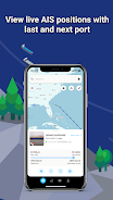
Extensive Tracking & Trade Data: Access detailed information on port operations, sea routes, marine weather, ice conditions, piracy hotspots, and nautical maps.
-
High-Accuracy Data: Rigorous data processing ensures the accuracy and reliability of the AIS data.
-
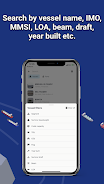
Advanced Vessel Search: Search for vessels using names, IMO or MMSI numbers, or port names and types. Refine searches using additional criteria like LOA, beam, draft, and year built.
-
Sea Route Calculation: Easily calculate estimated time of arrival (ETA), distance (nautical miles), time at sea, and projected fuel consumption for various routes.
-
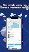
Customizable Vessel Tracking: Create unlimited vessel lists based on your search parameters and monitor their real-time positions on the map.
Summary:
ShipAtlas from Maritime Optima is an intuitive application delivering real-time AIS position data and a wealth of shipping and trade-related information. Its high-quality data, simple interface, and features such as the sea route calculator make it an invaluable asset for anyone involved in vessel tracking. While many features are free, a paid subscription unlocks additional capabilities. Download ShipAtlas today to explore the world of maritime data and navigation. Learn more on our website.