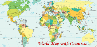
The World Map With Countries app offers a user-friendly exploration of global geography and political boundaries. It provides a comprehensive visual representation of continents, countries (including transcontinental and island nations), territories, oceans, seas, and more, all clearly marked with administrative boundaries and geographic coordinates (meridians and parallels). This detailed political world map showcases 197 countries, their borders, and surrounding water bodies, serving as a valuable educational tool.
Features of the App:
- Visual World Map: A clear, graphical representation of the world's geography simplifies understanding of locations and boundaries.
- Comprehensive Country Data: Includes all continents, countries, territories, and islands, offering detailed information on each.
- Geographic Coordinate System: Displays meridians and parallels for a complete understanding of the geographic coordinate system.
- Precise Political Boundaries: Accurately depicts the administrative boundaries of all countries, highlighting both geographical and political divisions.
- Educational Resource: Serves as an informative and engaging tool for learning about global geography and political landscapes.
- Intuitive Interface: A simple, attractive design ensures ease of use and encourages exploration.
Conclusion:
The World Map With Countries app is an invaluable resource for anyone seeking to expand their geographical and political knowledge. Its visually rich interface, detailed country information, and user-friendly design make it perfect for students, travelers, and anyone curious about the world. Download the World Map With Countries app today and begin your global exploration! Learn about the seven continents: Asia, Africa, North America, South America, Antarctica, Europe, and Australia. Download the World Map With Countries app now!


