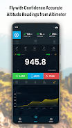
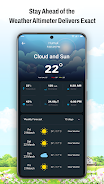
Introducing Altimeter GPS, the ultimate elevation app for adventurers and hikers. Easily check your altitude and precise location above sea level. Altimeter GPS provides a compass, altimeter, and elevation map, ensuring you never lose your way. Share your location with others for enhanced safety. The app features walking modes, a barometer for atmospheric pressure readings, and real-time weather updates including humidity, wind speed, and visibility. Elevate your hiking experience with Altimeter GPS. Download now and explore!
Features of the Altimeter GPS App:
- Altitude Meter: Accurately measures your altitude above sea level, tracking your elevation during travel or hikes.
- Compass Altimeter: A built-in compass aids navigation and location finding, preventing you from getting lost.
- Elevation Map: Visually displays your elevation on a map, providing a clear understanding of your altitude.
- Offline Tracking: Utilizing advanced barometric pressure technology, the app offers online and offline tracking, accessing satellite-based altitude data even in remote areas.
- Weather Updates: Displays current elevation and crucial weather information: humidity, air pressure, wind speed, temperature, and visibility.
- History and Flash Options: Saves your travel history, allowing you to revisit past hikes or resume walks from any point. A flash option ensures usability in low-light conditions.
Conclusion:
Altimeter GPS is an indispensable tool for adventurers and hikers needing precise altitude and location tracking. With its accurate altitude meter, compass, elevation map, offline tracking, weather updates, and history features, it provides everything for a safe and enjoyable outdoor experience. Whether beginner or expert, this app enhances your hiking adventures and prioritizes your safety. Download Altimeter GPS now and take your hiking to the next level.


